
Day 3
I woke early, partially because of the long day that lay ahead, and partially so I could enjoy a small breakfast from the hotel. After not eating the bagel I dropped onto my shoe (and subsequently kicked into a cabinet,) I ate some French toast and started to load the bike. The parking lot was filled with Mustangs, some new and some old, some basic and some special edition models. I stopped someone and asked him what the event was, because only an event would bring so many vehicles together like that. He told me it was a drive out west, in commemoration of the 50th anniversary of the Mustang’s debut on April 17th, 1964. While it was cool, it reminded me of the antique looking Ford dealership I was supposed to see in Tazewell, Va on my first day, something sacrificed for time and weather. With the bike loaded, I set off and immediately, the near freezing temps bit into my neck. The heated gear and insulated pants worked well, keeping the rest of me warm, but my neck was exposed to the temps and freeway speeds as I took I-40 to escape the city. I debated stopping and buying something to insulate it, but the more I rode I started to notice it didn’t feel as bad. I attributed it to my neck going numb.
A few miles outside of town, I happily traded the interstate for the Great Smokey Mountains Expressway, beginning a scenic drive through the mountains. Despite the slightly slower speeds, I soon found the cold beginning to eat its way into my feet. I took an exit shortly before Bryson City and meandered down a narrow two-lane road to find a gas station where I could stop to put on an extra layer of socks. The station I found had a rustic, general store look to it, complete with rocking chairs outside. But it was far too cold for that, so I walked inside.

“Do you have a chair I could borrow for a few minutes?” I asked.
“No, but you can use my stool” she responded, walking over to the edge of the counter carrying the barstool she had been sitting on.
As I took off my shoes, she and I started talking about my trip, asking me if I was planning to ride the Tail of the Dragon. Originally, I was planning to, but since I had to reach the far end of Tennessee before the end of the day, I told her I was uncertain. A map was handed to me as I put on my second pair of socks, recommending the Cherohala Skyway instead. She described it as being every bit as scenic as the Dragon, but with more time to actually take in the scenery between each turn. I looked at the route, surprised to see it end in Tellico Plains, and decided it was direct enough to get me to where I was headed, but scenic and twisty enough to interest me. I laced up my boots, thanked her, and started to leave when she offered me a free cup of coffee to help warm me up. Not being much of a coffee drinker, I politely declined and walked outside to my bike.
I set off again, following the directions she had given me, recognizing the names of landmarks she had mentioned, and soon I saw signs for the skyway itself. I stopped to take a few photographs of the landscape, awed by the layers of rolling ridgelines as they faded into the blue sky. I decided this was how the Blue Ridge Mountains earned their name.

The road was scenic, twisting along the Appalachians, climbing and descending over the hills. I watched my GPS’s altimeter climb higher and higher. 2000 feet, 3000 feet, 4000 feet, and finally as I approached the Tennessee border, I hit the mile high point. I felt elated: It was a beautiful (but cold) day, and I had never taken the bike this high up before, but now I had and it was performing admirably.As I made my way down to lower elevations, I started playing tag with a pair of Harley riders. I’d pass them when they stopped to take photos, and they’d pass me when I’d stop to admire the scenery around me, or when they’d speed past me anxious to get to the Harley dealer on the outskirts of Tellico Plains. It wouldn’t be the last time that I’d wonder why more people didn’t take the time to enjoy the scenery around them instead of simply rushing through.
The road suddenly turned to spring as it ran alongside the river near Tellico Plains, with not a cloud in sight to keep the midday sun from shining on the trees and flowers in bloom. I traveled into town where I stopped for lunch, finally reaching the destination I was supposed to have been at the night before.
I had planned on taking the Trans-America Trail westward, but with the delay in Asheville, I no longer had the time. I felt okay with it though, knowing I’d meet up with my schedule later that night. So, fed and fueled, I headed out onto some local roads, aiming myself towards the Interstate in effort to cover a large block of distance fast. Compared to the casual meanderings of the local roads, I-75 was a rushing torrent of wind, and I tucked in as best I could on the naked bike trying to streamline myself. Surprisingly, the freeway dipped into Georgia for a few miles before turning back into Tennessee, allowing me to add another state to my growing list of places been.
At highway speeds, the Scrambler guzzles gas. An exaggeration, since even 40 something miles to the gallon can hardly be described as bad mileage, but the bike does do significantly worse at 75mph than it does at 55. As I exited off the highway for my fuel stop, I noticed my right foot sinking further and further with each press of the brake. I pulled up to the pump, hopped off the bike, and began to investigate.
At first I didn’t see it, never expecting it to happen, but then I realized my caliper was not where I had last left it, instead rotated off of the rotor, pads squeezed tight together. Apparently, in my rush to get out of the cold the day before, I never fully tightened the caliper retaining bolts, and one of them had worked its way loose over the morning. I cracked open my toolkit again, and used my tire levers to pry apart the brake pads and give me space to reseat the caliper. Without another bolt to use, I silently thanked whoever it was that had first mentioned putting zip ties in the tool kit, and zip tied my caliper in place. Shortly before leaving on my trip, I had bought a new survival knife and now I christened its blade buy cutting the excess from the zip tie. It wouldn’t survive regular use, but I felt confident that my brake could be used in an emergency. Still, I needed a bolt.
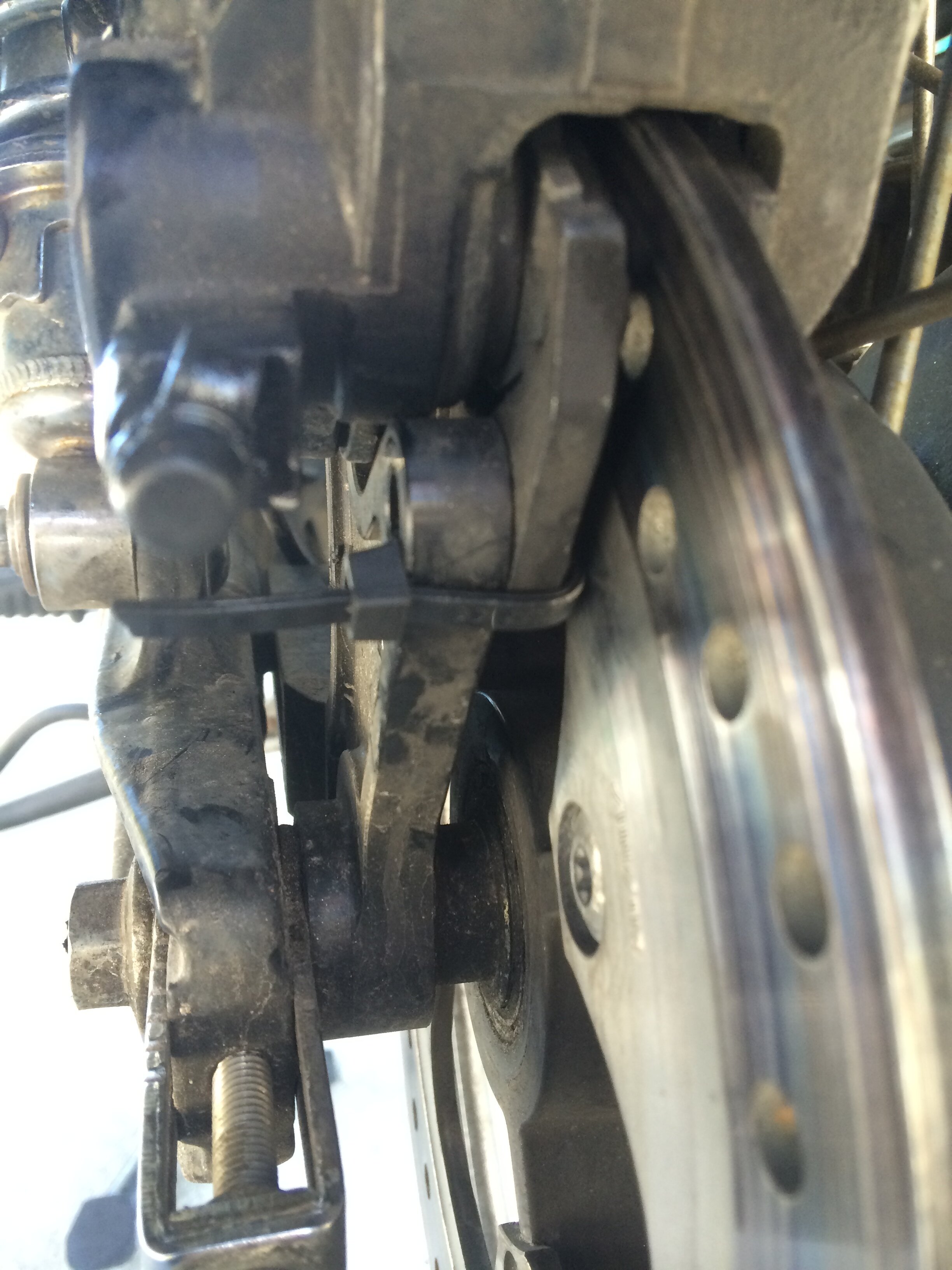

I took US-64, passing the Nissan North America factory on my way into the nearby town of Winchester, hoping to find an AutoZone. Rolling through the historic looking downtown, a place that would’ve looked nice 30-50 years ago but now seemed passed its prime, my GPS pointed me towards a nearby parts store. I pulled into the parking lot and removed my remaining caliper bolt so that I could find its mate inside. Fortune didn’t favor me however, and I was forced to keep the zip tie in place. I reinstalled my bolt, ensuring it was as tight as possible, and set off back through the antique downtown.
I passed through the rolling grass lands of southern Tennessee and began to see signs for the Jack Daniels distillery in Lynchburg. Had I been on schedule I would’ve stopped, but things being as they were, I pressed on.
The sun was beginning to set as I pulled off US-64 to follow the signs for Pickwick Landing State Park, casting the shadow of my bike and I upon the fields beside me. The signs led me past the park’s inn and marina, directing me to the campground where a slip of paper was holding my site for me.
I parked the bike and began to set up the camp, after first struggling with the years-old knot holding my tent bag closed. Moments later, the tent was pitched, and I off-loaded the bike, stashing my gear inside.
